Mantrailing needs clean preparation and precise review. RescueDogs keeps runner route, laying time, environment, dog work and deviations together.
Track planner and freehand mode
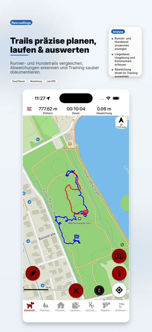
Runner trails can be prepared, shared and used for a recording. Route guidance helps where paths should be followed; freehand mode helps in fields, terrain or unmarked passages.
Preparation
Plan a trail, see length, correct points and record start coordinates.
Recording
Show the planned or recorded runner trail during the dog trail.
Crosstrack
Make deviations between dog and runner visible.
Export
Export trails with time and length as GPX.
Better review after the run
After the search, trails can be viewed, commented and rated. Runner trail and dog trail can be shown together for a clear debrief.
Mantrailing in the team
Organizations can share planned trails so trainers, runners and handlers work from the same foundation.
Your first trail in three steps
- Choose or plan a trail
Start with your own runner trail. Use RescueDogs on your own first and connect with your team later.
- Record the dog trail
Select the matching runner trail and record the search. Use your phone or a supported dog tracker when needed.
- Keep one useful observation
Review the route and add a rating and note: what went well, and what will you practise next time?
Already part of a team? Ask your administrator for an invitation code or QR code. You do not need to create a second organization.
Prepare your maps before training
Premium offline maps can be downloaded in advance with Mapbox. Other map providers may cache viewed tiles; this is not a reliable offline download. Check your prepared area in airplane mode before heading out.
Before your first session
Do I need an organization to get started?
No. You can start with your own trails and recordings. Join your existing team later using its invitation code or QR code.
Can I prepare maps for poor reception?
With Premium, download Mapbox offline maps or import compatible MBTiles/PMTiles raster packages. Check your area in airplane mode before leaving.
Your next training step, close at hand
Record trail age, false alerts and assistance when useful. The spatial comparison also works when the runner laid the trail earlier. It measures distance to the recorded runner route; GPS accuracy and missing fixes limit what you can conclude. It is not a score for the dog’s work.
Mantrailing that does not end after the run.
Turn each trail into a reusable training record.